Kerry Camino
The route of the Kerry Camino From Tralee to Camp Section DAY 1 OF 3 DAYS
Distance: 18km | Ascent: 200m | Time: 5 - 7 hrs
The Kerry Camino starts and finishes in Tralee at St John's church. A sign for the official start can be found at the church entrance. A quick stroll through the park will lead to Princes Street where a left turn continues through Princes Quay and on to a busy roundabout. Turning right here will set the Kerry Camino in motion as the trail quickly escapes the town traffic by joining the gentle curve of the canal path for 2km to Blennerville.The first of the stamping stations can be found at the town end of the canal.
The walk along the canal comes to an end upon reaching a bridge opposite the Blennerville Windmill. At this point, the Kerry Camino branches off from a second trail called the 'North Kerry Way' and crosses the canal to approach the village.
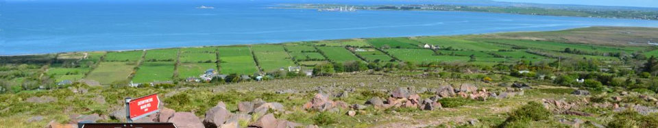
The Kerry Camino follows the main N86 road to Dingle for a short distance when passing through Blennerville. After crossing the canal, the trail takes the second left turn and follows some quieter country back roads that gradually start to rise up into the flanks of the Slieve Mish mountain range. After around 3km, the trail eventually reaches Tonevane and sharply turns west and out into the open mountainside.
The following section of the Kerry Camino can get quite marshy and is dotted with large red sandstone rocks which have been laid for use as stepping stones A pair of gaiters is of great advantage as its almost inevitable that at some point a foot will go astray and end in bog that could be ankle-deep!
As the Kerry Camino passes the entrances to several impressive glacial valleys, a number of streams make their way towards the sea. These are easily crossed by either bridge or stepping stones. Features of interest to keep an eye out for along this mountain section are an old Victorian-era reservoir that used to supply water to Tralee. Towards the end of this section the trail descends onto a hedge-lined stone path which used to be the old Tralee-Dingle road in the distant past. The preserved ruins of Killelton Oratory can be found alongside the trail here to the left of the path. This part is often used as a cattle drove which means it can get quite mucky. Several stiles have to be crossed before finally reaching a tarmac road.
The final section of the walk comes down into a valley, crosses the Finglas River and takes in a short uphill stretch before meeting a minor road.. The turn to the right leads downhill for around 1km to Camp Village. The road straight ahead continues in the direction of Dingle.This village is ideal for your first overnight and whether it is simply resting over a pint and sharing the experiences of the day or enjoying some of the local characters and eateries you are sure not to be disappointed
View The Kerry Camino Tralee To Camp Leg in a larger map
This is a an approximate outline of the route. On the ground the route is marked by stakes


